Walk name: Molonglo Meanderings
Location: 10km southwest of Canberra.
Walk distance: 12km
Description: An easy walk, beginning at Deeks Forest Park carpark off Uriarra Road, close to the Cotter Road junction. The route heads NE on fire access trails and the National Bicentennial Trail. Loop around Janson Road. Cross over the Molonglo River at Southwells Crossing. Head N and then up to the top of Misery Hill; W down to Misery Point, cross back over the river into private land. Detour via site of Mrs Blundells House, then S cross country to Coppins Crossing Road x Uriarra Road [Copiarra gate]. Through the bottom of Stromlo Forest Park and via the Canberra Bushfire Memorial and E back to the car.
Walk map: NSW topographic map 1:25000 Canberra 8727-3N 2nd edition.
Start Grid ref:FA847892
Start GPS: [UTM Zone 55H] E684767,N6089180
Locality map from Geoscience Australia MapConnect 250K topo base:
Satellite image from ACTMAPi:
Google Earth: KMZ file
Day & date: Wednesday 2009 March 04
0900
Start time: 0900
Walking time: 4h
Weather: Sunny, mild, windy 23C
Sun: Rise 0645,transit 13:15,set 1930.
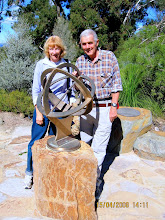
Set out with neighbour Reg Sewrey for company. Easily followed map and GPS to lookout over the river at Murrays Turnaround. Survey marker along Janson Drive. Shortcut to Southwells Crossing. Barely a trickle of water in the river. Climb to top of Misery Hill for panoramic view. Blackberries ripe & sweet to eat. Down to Misery Point, passing survey control mark ST 232. Lunch beside the river in company of a herd of feral goats! Easy to cross river, scramble up hill to see site of Mrs Blundells House [E685042, N6090912] marked by a prominent clump of trees. Only a brick fireplace and bread oven left. Private property, but closed all gates behind us and went undisturbed through paddocks. Over the Coppiarra Gate, across the Uriarra Road and into an empty Stromlo Forest Park. Called in to the Canberra Bushfire Memorial [E684247, N6089135]...all the more poignant after the recent fire disaster in Victoria. Back to car. Bonus side trip up to top of Mt Stromlo where I got a GPS fix on MC Stromlo Trig [E682765, N6090037]. Absolutely spot on. Stromlo ECCE 1 just a few meters away. Visitors centre closed and derelict but the garden sundial survived. A great day out!
Wednesday, March 4, 2009
Subscribe to:
Posts (Atom)